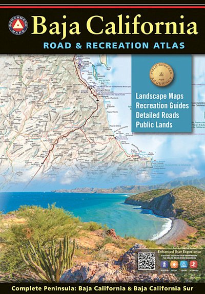
BAJA CALIFORNIA ROAD & RECREATION ATLAS
£25.99
|
|
Since 1995, Benchmark Maps has been driving and mapping the American West, publishing award-winning recreation maps and atlases. The first edition Baja California Road & Recreation Atlas showcases the diverse recreation opportunities found along the full length of the Baja California Peninsula. State maps illustrate and describe both states, Baja California & Baja California Sur. Regional maps provide a wider view of the region and Recreation Guides list an array of attractions for trip planning. Landscape Maps- provide the most detail, bringing the peninsula's rugged terrain into focus with land cover data, shaded relief, and a detailed road network to aid travelers navigating between cities or seeking remote destinations.
Landscape Maps
Large scale maps with detailed road classifications, points-of-interest, landmarks, elevations
Kilometer markers on major highways
Page-to-page map overlap, clear legibility
National Parks and Wildlife Areas
Recreation Guides
Regional maps at medium scale illustrate broader views and longer routes
Focused maps & listings for La Paz, Los Cabos Corridor, and wineries of Valle de Guadalupe
Recreation categories include:
Parks, Monuments, Natural Wonders
Boating & Fishing Access, Beaches
Historic Missions & Ruins
Campgrounds & RV Parks
In Stock
Usually dispatched within 24 hrs. Free delivery to UK for orders £25 and over.
£25.99
Cordee Code: CMA548
No of Pages: 72
Page Size: 275 x 387 mm
ISBN 10: 1734315059
ISBN 13: 9781734315059
Publisher: Benchmark Maps
Published Date: May 2021
Edition: 1st ed, 2021
Binding: Paperback
Illustrations: Colour mapping throughout
Weight: 400g
|


 Accommodation Guides